

Weather
- Interactive Map
- Market Impact
- Hourly Forecast
Weather Blogs & Columns

Ensure field work efficiency
Get ultra-local insights from an on-site weather station to:
- Protect your yields
- Time spraying & irrigation
- Reduce operational costs
DIM[1x3] LBL[weather-interactive-map-box] SEL[] IDX[] TMPL[standalone] T[]

NEW! Keep applications on target
Minimize drift & inversion risks with Spray Outlook, a new enhancement added to MyDTN.
- Avoid legal issues
- Protect your margins
- Maximize spray windows
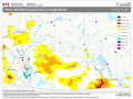
Market Weather Factors
- CORN
- SOYBEANS
- WHEAT
This is not presented as a commodity trading recommendation. Weather is only one of many factors which can influence the market on any given day.
To view more market impact weather information, click here
Weather News Headlines

5-Day Weather
Outlook
Want to save your postal code for future use?